
Mapa topográfico Dunedin
Haga clic en el mapa para ver la altitud.
Dunedin
Dunedin is characterized by a predominantly flat terrain, with an average elevation of approximately 13 feet (4 meters) above sea level, making it typical of the coastal regions of Pinellas County. The area's topography is defined by its proximity to the Gulf of Mexico, which influences its gently rolling landscapes and provides a variety of waterfront features. The city includes several parks and natural reserves, such as the Honeymoon Island State Park, where elevation can slightly rise to around 40 feet (12 meters). Overall, the relatively low-lying nature of Dunedin contributes to its susceptibility to flooding, particularly during heavy rainfall or tropical storms.
Acerca de este mapa
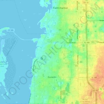
Nombre: Mapa topográfico Dunedin, altitud, relieve.
Lugar: Dunedin, Pinellas County, Florida, 34698, United States (27.99727 -82.83778 28.08427 -82.73848)
Altitud media: 11 m
Altitud mínima: -1 m
Altitud máxima: 35 m
Otros mapas topográficos
Haga clic en un mapa para ver su topografía, su altitud y su relieve.
Palm Harbor
United States > Florida > Pinellas County
Palm Harbor is characterized by its unique topography, which features a relatively rare hilly landscape for the region. Unlike much of the surrounding areas in Pinellas County, which are predominantly flat, Palm Harbor includes elevations that can reach up to about 75 feet above sea level. This elevation gives…
Altitud media: 9 m
Fort De Soto County Park
United States > Florida > Pinellas County > Saint Petersburg
Altitud media: 0 m
Saint Petersburg County Park
United States > Florida > Pinellas County > Saint Pete Beach
Altitud media: 1 m
Splash Harbour Water Park
United States > Florida > Pinellas County > Indian Rocks Beach
Altitud media: 4 m
Boyd Hill Nature Preserve
United States > Florida > Pinellas County > Saint Petersburg > Lakewood Estates
Altitud media: 7 m
Lealman
United States > Florida > Pinellas County
Lealman is located at 27°49′10″N 82°41′4″W / 27.81944°N 82.68444°W / 27.81944; -82.68444 (27.8197, -82.6846). The community is bordered by the city of Pinellas Park to the north, St. Petersburg to the east and south, and by the town of West Lealman to the west. The elevation is 49 feet (15…
Altitud media: 13 m
Boyd Hill Nature Preserve
United States > Florida > Pinellas County > Saint Petersburg > Lakewood Estates
Altitud media: 7 m