
Mapa topográfico Bellingham
Mapa interactivo
Haga clic en el mapa para ver la altitud.
Acerca de este mapa
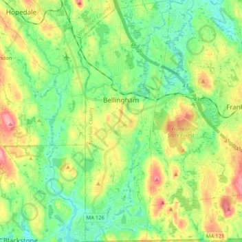
Nombre: Mapa topográfico Bellingham, altitud, relieve.
Altitud media: 84 m
Altitud mínima: 45 m
Altitud máxima: 153 m
According to the United States Census Bureau, the town has a total area of 19.0 square miles (49.2 km2), of which 18.5 square miles (47.9 km2) is land and 0.5 square mile (1.3 km2) (2.58%) is water. The town's mean elevation is 293 feet (89 m) above sea level.
Otros mapas topográficos
Haga clic en un mapa para ver su topografía, su altitud y su relieve.
Wethersfield
United States > Massachusetts > Norfolk County > Bellingham
Wethersfield, Bellingham, Norfolk County, Massachusetts, 02019, United States
Altitud media: 76 m