
Mapa topográfico Alys Beach
Haga clic en el mapa para ver la altitud.
Acerca de este mapa
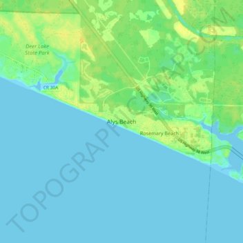
Nombre: Mapa topográfico Alys Beach, altitud, relieve.
Lugar: Alys Beach, Walton County, Florida, 32461, United States (30.24413 -86.07001 30.32413 -85.99001)
Altitud media: 5 m
Altitud mínima: -4 m
Altitud máxima: 18 m
Otros mapas topográficos
Haga clic en un mapa para ver su topografía, su altitud y su relieve.
Paxton
United States > Florida > Walton County
Paxton is a town in Walton County, Florida, United States. The population was 644 as of the 2010 census. Located near Britton Hill on the Alabama–Florida state line, the town has the highest elevation of any in Florida.
Altitud media: 82 m
Paxton
United States > Florida > Walton County
Paxton is a town in Walton County, Florida, United States. Located near Britton Hill on the Alabama–Florida state line, it has the highest elevation of any in Florida. The Town of Paxton is located on the Florida Panhandle, and is part of the Crestview–Fort Walton Beach–Destin, Florida Metropolitan…
Altitud media: 82 m
Choctaw Beach Community Center Park
United States > Florida > Walton County > Freeport > Choctaw Beach
Altitud media: 7 m