
Haz una donación
Mapa topográfico Ventura
Haga clic en el mapa para ver la altitud.
Haz una donación
Acerca de este mapa
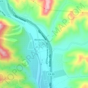
Nombre: Mapa topográfico Ventura, altitud, relieve.
Lugar: Ventura, Ventura County, California, United States (34.34250 -119.29721 34.34468 -119.29411)
Altitud media: 120 m
Altitud mínima: 42 m
Altitud máxima: 302 m
Haz una donación
Otros mapas topográficos
Haga clic en un mapa para ver su topografía, su altitud y su relieve.
Haz una donación
Newbury Park
United States > California > Ventura County > Thousand Oaks
Newbury Park can be described as a town,[6] community,[94] or section[9] mostly within the Thousand Oaks city limits in addition to rural areas west of Thousand Oaks. Newbury Park is bordered by Lynn Road in the east and the Conejo Grade on the west. It borders the Santa Monica Mountains in the south, while…
Altitud media: 262 m
Haz una donación
Haz una donación
Haz una donación
Haz una donación
Casitas Springs
United States > California > Ventura County > Ventura > Casitas Springs
Altitud media: 182 m
Castlewood at Big Sky
United States > California > Ventura County > Simi Valley > Castlewood at Big Sky
Altitud media: 360 m
Haz una donación
Ventu Park
United States > California > Ventura County > Thousand Oaks > Newbury Park
Altitud media: 250 m