
Gracias por apoyar a este sitio ❤️
Haz una donación
Haz una donación
Mapa topográfico Fairview
Haga clic en el mapa para ver la altitud.
Gracias por apoyar a este sitio ❤️
Haz una donación
Haz una donación
Fairview
The terrain is hilly to gently rolling, with elevations ranging from 200 feet near the Don Castro Regional Recreation Area (a park within the East Bay Regional Park District) to nearly 1,100 feet along Fairview Avenue.
Gracias por apoyar a este sitio ❤️
Haz una donación
Haz una donación
Acerca de este mapa
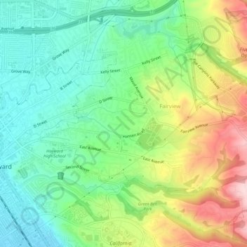
Nombre: Mapa topográfico Fairview, altitud, relieve.
Lugar: Fairview, Alameda County, California, United States (37.65576 -122.07290 37.69570 -122.02398)
Altitud media: 123 m
Altitud mínima: 19 m
Altitud máxima: 305 m
Gracias por apoyar a este sitio ❤️
Haz una donación
Haz una donación