
Mapa topográfico Albany
Mapa interactivo
Haga clic en el mapa para ver la altitud.
Acerca de este mapa
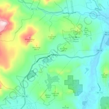
Nombre: Mapa topográfico Albany, altitud, relieve.
Lugar: Albany, Carroll County, New Hampshire, United States (43.91998 -71.23296 43.99998 -71.15296)
Altitud media: 276 m
Altitud mínima: 136 m
Altitud máxima: 709 m
According to the United States Census Bureau, the town has a total area of 75.8 square miles (196.2 km2), of which 75.1 square miles (194.6 km2) are land and 0.58 square miles (1.5 km2) are water, comprising 0.79% of the town. It is drained by the Swift River in the north and the Chocorua River in the south. The town lies fully within the Saco River watershed. Mount Chocorua, the highest point in Albany, has an elevation of 3,474 feet (1,059 m), and Mount Paugus has an elevation of 3,201 ft (976 m).
Otros mapas topográficos
Haga clic en un mapa para ver su topografía, su altitud y su relieve.
Whitton Pond
United States > New Hampshire > Carroll County > Albany
Whitton Pond, Albany, Carroll County, New Hampshire, United States
Altitud media: 273 m
Albany
United States > New Hampshire > Carroll County > Albany
Albany, Carroll County, New Hampshire, 03818, United States
Altitud media: 409 m