
Mapa topográfico Tessy-sur-Vire
Mapa interactivo
Haga clic en el mapa para ver la altitud.
Acerca de este mapa
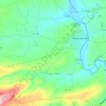
Nombre: Mapa topográfico Tessy-sur-Vire, altitud, relieve.
Altitud media: 93 m
Altitud mínima: 35 m
Altitud máxima: 248 m
Otros mapas topográficos
Haga clic en un mapa para ver su topografía, su altitud y su relieve.
50420
France > Normandie > Manche > Tessy-Bocage
50420, Tessy-sur-Vire, Tessy-Bocage, Saint-Lô, Manche, Normandie, France métropolitaine, France
Altitud media: 73 m
Les Hauts Vents
France > Normandie > Manche > Tessy-Bocage
Les Hauts Vents, Pont-Farcy, Tessy-Bocage, Saint-Lô, Manche, Normandie, France métropolitaine, 14380, France
Altitud media: 104 m
Beau Costil
France > Normandie > Manche > Tessy-Bocage
Beau Costil, Pont-Farcy, Tessy-Bocage, Saint-Lô, Manche, Normandie, France métropolitaine, 14380, France
Altitud media: 100 m
La Furetière
France > Normandie > Manche > Tessy-Bocage
La Furetière, Tessy-sur-Vire, Tessy-Bocage, Saint-Lô, Manche, Normandie, France métropolitaine, 50420, France
Altitud media: 94 m
Le Moulin Sous Le Bois
France > Normandie > Manche > Tessy-Bocage > Le Moulin Sous Le Bois
Le Moulin Sous Le Bois, Pont-Farcy, Tessy-Bocage, Saint-Lô, Manche, Normandie, France métropolitaine, 14380, France
Altitud media: 98 m
Pont-Farcy
France > Normandie > Manche > Tessy-Bocage
Pont-Farcy, Tessy-Bocage, Saint-Lô, Manche, Normandie, France métropolitaine, 14380, France
Altitud media: 108 m
la campagne
France > Normandie > Manche > Tessy-Bocage > la campagne
la campagne, Tessy-sur-Vire, Tessy-Bocage, Saint-Lô, Manche, Normandie, France métropolitaine, 50420, France
Altitud media: 74 m