
Mapa topográfico Long Grove
Mapa interactivo
Haga clic en el mapa para ver la altitud.
Acerca de este mapa
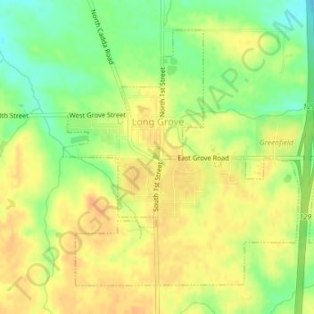
Nombre: Mapa topográfico Long Grove, altitud, relieve.
Lugar: Long Grove, Scott County, Iowa, United States (41.68401 -90.59424 41.70598 -90.56355)
Altitud media: 235 m
Altitud mínima: 213 m
Altitud máxima: 249 m
Otros mapas topográficos
Haga clic en un mapa para ver su topografía, su altitud y su relieve.
Davenport
United States > Iowa > Scott County
Davenport, Scott County, Iowa, United States
Altitud media: 205 m
Park View
United States > Iowa > Scott County
Park View, Scott County, Iowa, United States
Altitud media: 235 m
Buffalo
United States > Iowa > Scott County
Buffalo, Buffalo Township, Scott County, Iowa, 52728, United States
Altitud media: 205 m
Sheridan Township
United States > Iowa > Scott County
Sheridan Township, Scott County, Iowa, 52748, United States
Altitud media: 231 m
Bettendorf
United States > Iowa > Scott County > Pleasant Valley Township
Bettendorf, Pleasant Valley Township, Scott County, Iowa, 52722, United States
Altitud media: 207 m
Pleasant Valley Township
United States > Iowa > Scott County
Pleasant Valley Township, Scott County, Iowa, United States
Altitud media: 198 m
Le Claire
United States > Iowa > Scott County
Le Claire, Le Claire Township, Scott County, Iowa, United States
Altitud media: 200 m
Walcott
United States > Iowa > Scott County > Walcott
Walcott, Blue Grass Township, Scott County, Iowa, United States
Altitud media: 227 m
Eldridge
United States > Iowa > Scott County
Eldridge, Sheridan Township, Scott County, Iowa, 52748, United States
Altitud media: 234 m
Davenport
United States > Iowa > Scott County > Davenport
Davenport, Scott County, Iowa, 52801, United States
Altitud media: 212 m
Blue Grass
United States > Iowa > Scott County
Blue Grass, Blue Grass Township, Scott County, Iowa, United States
Altitud media: 239 m