
Haz una donación
Mapa topográfico Delamere Forest
Haga clic en el mapa para ver la altitud.
Haz una donación
Delamere Forest
This part of Delamere Forest is undulating in character, with elevations predominantly in the range 60–90 metres. It is composed of numerous hummocks and peatland basins, some of which are glacial in origin while others have been created by sand extraction. The basins form lakes and mosses (bogs) within the forest, the largest of which is Blakemere Moss, which originated in two glacial kettle holes and is now a lake around 1 km in length. Other sizeable wetlands include Black Lake, Dead Lake and Linmer Moss. This forest area has several named local high points, including Hart Hill, Hunger Hill and Manley Hill.
Haz una donación
Acerca de este mapa
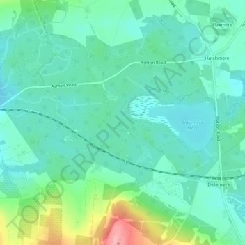
Nombre: Mapa topográfico Delamere Forest, altitud, relieve.
Altitud media: 90 m
Altitud mínima: 62 m
Altitud máxima: 177 m
Haz una donación
Otros mapas topográficos
Haga clic en un mapa para ver su topografía, su altitud y su relieve.
Frodsham
United Kingdom > England > Cheshire West and Chester
Several faults run roughly northwest–southeast through the area, notably the Overton Fault, which roughly parallels the B5439 and B5152 roads, and the Frodsham Fault, which runs north from the vicinity of Crowmere to the mouth of the River Weaver. Both of these faults and others in the area downthrow to the…
Altitud media: 49 m
Haz una donación
Countess of Chester Country Park
United Kingdom > England > Cheshire West and Chester > Chester
Altitud media: 21 m
Haz una donación
Haz una donación
Bolesworth Fish Pond
United Kingdom > England > Cheshire West and Chester > Harthill > Broxton
Altitud media: 75 m
Haz una donación
Wirral Country Park
United Kingdom > England > Cheshire West and Chester > Neston > Windle Hill
Altitud media: 49 m
Haz una donación
Peckforton Castle
United Kingdom > England > Cheshire West and Chester > Beeston
Peckforton Castle stands in a wooded area near the northern extremity of Peckforton Hills at an elevation of 469.2 feet (143 m). The land falls steeply downwards to the north and the west of the castle, and the Sandstone Trail, a long-distance footpath, runs along the base of these slopes. The ruins of Beeston…
Altitud media: 83 m
Haz una donación
Little Stanney
United Kingdom > England > Cheshire West and Chester > Ellesmere Port
Altitud media: 21 m
Haz una donación
Dutton Small Lock (Disused)
United Kingdom > England > Cheshire West and Chester > Acton Bridge > Dutton
Altitud media: 28 m
Haz una donación
Haz una donación
Haz una donación
Haz una donación
Haz una donación
Haz una donación
Haz una donación
Haz una donación
Haz una donación
Haz una donación
Haz una donación
Haz una donación
Haz una donación
Haz una donación
Haz una donación
Haz una donación