
Gracias por apoyar a este sitio ❤️
Haz una donación
Haz una donación
Mapa topográfico Stockton
Haga clic en el mapa para ver la altitud.
Gracias por apoyar a este sitio ❤️
Haz una donación
Haz una donación
Stockton
The village water tower sits on a ridge at elevation 1,105 ft (337 m) that rises to 1,120 ft (340 m) to the west at the village limits. To the northwest the same ridge line continues where U.S. Route 20 crests at 1,077 ft (328 m) just to the west. This ridge line continues for 3 miles to the northwest to Benton Mound (1,204 ft; 367 m ), the second highest peak in Illinois.
Gracias por apoyar a este sitio ❤️
Haz una donación
Haz una donación
Acerca de este mapa
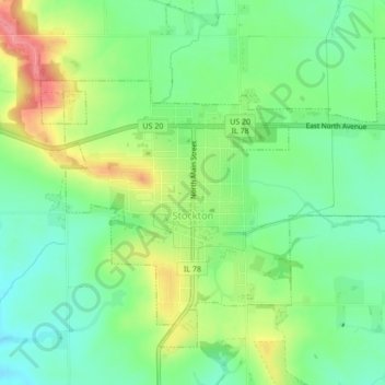
Nombre: Mapa topográfico Stockton, altitud, relieve.
Altitud media: 301 m
Altitud mínima: 267 m
Altitud máxima: 356 m
Gracias por apoyar a este sitio ❤️
Haz una donación
Haz una donación
Otros mapas topográficos
Haga clic en un mapa para ver su topografía, su altitud y su relieve.