
Mapa topográfico Bayog
Mapa interactivo
Haga clic en el mapa para ver la altitud.
Acerca de este mapa
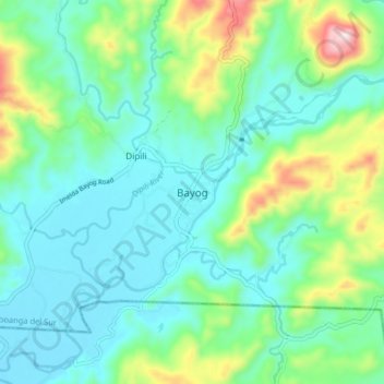
Nombre: Mapa topográfico Bayog, altitud, relieve.
Lugar: Bayog, Zamboanga del Sur, Zamboanga Peninsula, Philippines (7.80892 123.00393 7.88892 123.08393)
Altitud media: 136 m
Altitud mínima: 26 m
Altitud máxima: 485 m
The town is partly situated in the Sibougey Valley watered by the Sibuguey River, Dipili River, and Depore River. 75% of the land lies on rugged terrain with elevation up to 300 metres (980 ft).