
Mapa topográfico Sint-Pietersberg
Mapa interactivo
Haga clic en el mapa para ver la altitud.
Acerca de este mapa
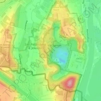
Nombre: Mapa topográfico Sint-Pietersberg, altitud, relieve.
Altitud media: 71 m
Altitud mínima: 10 m
Altitud máxima: 153 m
Otros mapas topográficos
Haga clic en un mapa para ver su topografía, su altitud y su relieve.
Meuse
Netherlands > Limburg > Maastricht > Borgharen
Meuse, Borgharen, Maastricht, Limburg, Netherlands, 6223 AB, Netherlands
Altitud media: 48 m
Maastricht
Netherlands > Limburg > Maastricht
Maastricht, Limburg, Netherlands, 6211CS, Netherlands
Altitud media: 101 m