
Gracias por apoyar a este sitio ❤️
Haz una donación
Haz una donación
Mapa topográfico Fairview
Haga clic en el mapa para ver la altitud.
Gracias por apoyar a este sitio ❤️
Haz una donación
Haz una donación
Fairview
Fairview was incorporated on July 28, 1959, under the Uniform City Manager-Commission Charter as set out in the Tennessee Code Annotated. Fairview city limits are located about one mile (1.6 km) southwest from the Nashville-Davidson County line and has two interstates passing through it (I-40 & I-840). With an average elevation of 800 feet (240 m) above sea level, Fairview is about 150 feet (46 m) higher than Nashville and surrounding suburbs, which gives Fairview the advantage of being less flood prone.
Gracias por apoyar a este sitio ❤️
Haz una donación
Haz una donación
Acerca de este mapa
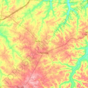
Nombre: Mapa topográfico Fairview, altitud, relieve.
Altitud media: 233 m
Altitud mínima: 164 m
Altitud máxima: 287 m
Gracias por apoyar a este sitio ❤️
Haz una donación
Haz una donación
Otros mapas topográficos
Haga clic en un mapa para ver su topografía, su altitud y su relieve.
Gracias por apoyar a este sitio ❤️
Haz una donación
Haz una donación
Gracias por apoyar a este sitio ❤️
Haz una donación
Haz una donación
Gracias por apoyar a este sitio ❤️
Haz una donación
Haz una donación
Gracias por apoyar a este sitio ❤️
Haz una donación
Haz una donación
Gracias por apoyar a este sitio ❤️
Haz una donación
Haz una donación