
Mapa topográfico Koshi
Mapa interactivo
Haga clic en el mapa para ver la altitud.
Acerca de este mapa
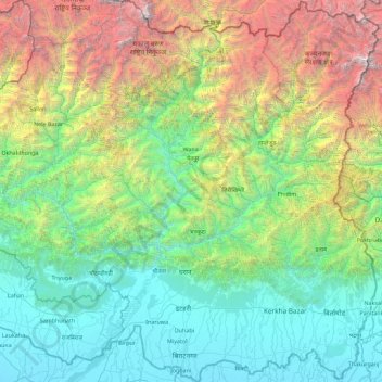
Nombre: Mapa topográfico Koshi, altitud, relieve.
Lugar: Koshi, Eastern Development Region, Nepal (26.34776 86.89317 27.95792 87.75151)
Altitud media: 1.899 m
Altitud mínima: 55 m
Altitud máxima: 8.489 m
Otros mapas topográficos
Haga clic en un mapa para ver su topografía, su altitud y su relieve.
Mount Everest
Nepal > Eastern Development Region > Khumjung
Mount Everest, Khumjung, Khumbupasanglahmu, Solukhumbu, Province #1, Nepal
Altitud media: 7.841 m
Lhotse Shar
Nepal > Eastern Development Region > Khumjung
Lhotse Shar, Khumjung, Solukhumbu, Sagarmatha, Eastern Development Region, Nepal
Altitud media: 7.153 m
Mechi
Nepal > Eastern Development Region
Mechi, Eastern Development Region, Nepal
Altitud media: 1.902 m
Mahalangur Himal
Nepal > Eastern Development Region > Makalu
Mahalangur Himal, Makalu, Sankhuwasabha, Koshi, Eastern Development Region, Nepal
Altitud media: 4.695 m
Island Peak
Nepal > Eastern Development Region > Khumjung
Island Peak, Khumjung, Solukhumbu, Sagarmatha, Eastern Development Region, Nepal
Altitud media: 5.461 m
Khumbu Glacier
Nepal > Eastern Development Region > Khumjung > Khumjung
Khumbu Glacier, Khumjung, Solukhumbu, Sagarmatha, Eastern Development Region, Nepal
Altitud media: 6.297 m