
Haz una donación
Mapa topográfico East Tennessee
Haga clic en el mapa para ver la altitud.
Haz una donación
East Tennessee
The Blue Ridge section comprises the western section of the Blue Ridge Province, the crests of which form most of the Tennessee-North Carolina border. At an average elevation of 5,000 feet (1,500 m) above sea level, this physiographic province contains the highest elevations in the state. The Blue Ridge region is subdivided into several subranges—the Iron Mountains, Unaka Range, and Bald Mountains in the north; the Great Smoky Mountains in the center; and the Unicoi Mountains, Little Frog Mountain, and Big Frog Mountain areas in the south. Kuwohi, at 6,643 feet (2,025 m), is the state's highest point and is located in the Great Smoky Mountains along the Tennessee-North Carolina border. Most of the Blue Ridge section is heavily forested and protected by various state and federal entities, the largest of which include the Great Smoky Mountains National Park and the Cherokee National Forest. The Appalachian Trail enters Tennessee in the Great Smoky Mountains and roughly follows the border with North Carolina most of the distance to near the Roan Mountain, where it shifts entirely into Tennessee.
Haz una donación
Acerca de este mapa
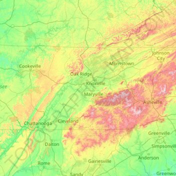
Nombre: Mapa topográfico East Tennessee, altitud, relieve.
Lugar: East Tennessee, Tennessee, United States (34.98294 -85.87303 36.61621 -81.64722)
Altitud media: 435 m
Altitud mínima: 123 m
Altitud máxima: 1.983 m
Haz una donación
Otros mapas topográficos
Haga clic en un mapa para ver su topografía, su altitud y su relieve.
Haz una donación
Haz una donación
Barfield Crescent Park
United States > Tennessee > Rutherford County > Murfreesboro
Altitud media: 201 m
Haz una donación
Haz una donación
Haz una donación
Haz una donación
Haz una donación
Haz una donación
Haz una donación
Haz una donación
Haz una donación
Haz una donación
Haz una donación
Haz una donación
Haz una donación
Haz una donación
Haz una donación
Haz una donación
Millersville City Park
United States > Tennessee > Robertson County > Millersville
Altitud media: 260 m
Haz una donación
Haz una donación
Haz una donación
Haz una donación
Haz una donación
Haz una donación
Haz una donación