
Mapa topográfico Waterton Park
Mapa interactivo
Haga clic en el mapa para ver la altitud.
Acerca de este mapa
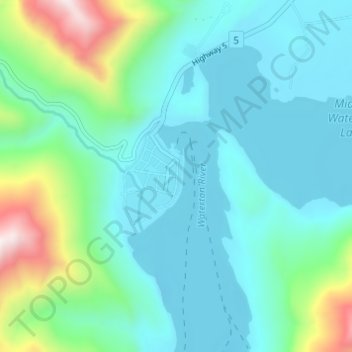
Nombre: Mapa topográfico Waterton Park, altitud, relieve.
Altitud media: 1.456 m
Altitud mínima: 1.269 m
Altitud máxima: 2.207 m
It is located at the southwestern terminus of Highway 5, approximately 54 kilometres (34 mi) west of the Town of Cardston and 55 kilometres (34 mi) south of the Town of Pincher Creek. This hamlet is north of Glacier National Park in Montana. It has an elevation of 1,280 metres (4,200 ft).
Otros mapas topográficos
Haga clic en un mapa para ver su topografía, su altitud y su relieve.
Mount Dungarvan
Canada > Alberta > Improvement District No. 04
Mount Dungarvan, Improvement District No. 04, Alberta, Canada
Altitud media: 2.065 m
Bertha Lake
Canada > Alberta > Improvement District No. 04
Bertha Lake, Improvement District No. 04, Alberta, Canada
Altitud media: 1.968 m