
Mapa topográfico Shigatse
Mapa interactivo
Haga clic en el mapa para ver la altitud.
Acerca de este mapa
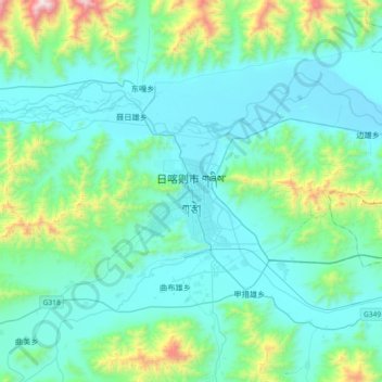
Nombre: Mapa topográfico Shigatse, altitud, relieve.
Altitud media: 4.055 m
Altitud mínima: 3.816 m
Altitud máxima: 5.363 m
Shigatse Peace Airport began operations on 30 October 2010 after an Airbus A319 landed safely, making it Tibet's fifth commercial airport. It is located 43 kilometres from Samzhubzê District at Jangdam Township at an elevation of 3,782 metres. The airport will be capable of supporting 230,000 passengers annually by 2020.[7]