
Mapa topográfico Oberhaid
Mapa interactivo
Haga clic en el mapa para ver la altitud.
Acerca de este mapa
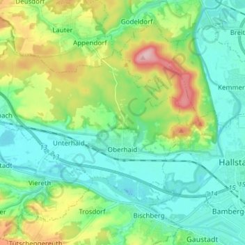
Nombre: Mapa topográfico Oberhaid, altitud, relieve.
Lugar: Oberhaid, Landkreis Bamberg, Bayern, 96173, Deutschland (49.91477 10.72112 49.96892 10.84614)
Altitud media: 275 m
Altitud mínima: 225 m
Altitud máxima: 407 m
Otros mapas topográficos
Haga clic en un mapa para ver su topografía, su altitud y su relieve.
Frensdorf
Deutschland > Bayern > Landkreis Bamberg
Frensdorf, Landkreis Bamberg, Bayern, 96158, Deutschland
Altitud media: 286 m
Viereth-Trunstadt
Deutschland > Bayern > Landkreis Bamberg
Viereth-Trunstadt, Landkreis Bamberg, Bayern, 96191, Deutschland
Altitud media: 288 m