
Mapa topográfico Garden Hill First Nation
Mapa interactivo
Haga clic en el mapa para ver la altitud.
Acerca de este mapa
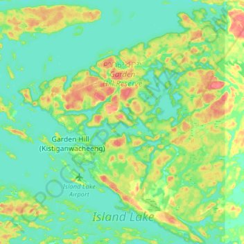
Nombre: Mapa topográfico Garden Hill First Nation, altitud, relieve.
Altitud media: 236 m
Altitud mínima: 222 m
Altitud máxima: 268 m
Otros mapas topográficos
Haga clic en un mapa para ver su topografía, su altitud y su relieve.
Island Lake
Canada > Manitoba > Garden Hill (Kistiganwacheeng) > Island Lake
Island Lake, Garden Hill (Kistiganwacheeng), Manitoba, Canada
Altitud media: 228 m