
Mapa topográfico Manchester
Mapa interactivo
Haga clic en el mapa para ver la altitud.
Acerca de este mapa
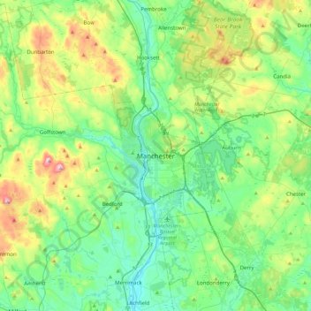
Nombre: Mapa topográfico Manchester, altitud, relieve.
Altitud media: 126 m
Altitud mínima: 28 m
Altitud máxima: 400 m
According to the United States Census Bureau, the city has a total area of 35.0 square miles (90.6 km2), of which 33.1 square miles (85.7 km2) are land and 1.9 square miles (4.8 km2) are water, comprising 5.33% of the city. Manchester is drained by the Merrimack River and its tributaries the Piscataquog River and Cohas Brook. Massabesic Lake is on the eastern border. The highest point in Manchester is atop Wellington Hill, where the elevation reaches 570 feet (170 m) above sea level.
Otros mapas topográficos
Haga clic en un mapa para ver su topografía, su altitud y su relieve.
Massabesic Lake
United States > New Hampshire > Hillsborough County > Manchester
Massabesic Lake, Manchester, Hillsborough County, New Hampshire, United States
Altitud media: 90 m