
Haz una donación
Mapa topográfico Cer
Haga clic en el mapa para ver la altitud.
Haz una donación
Cer
Cer (pronounced [tsɛr]) is a mountain in western Serbia, 30 kilometers from Šabac, 100 kilometers west of Belgrade. The highest peak has an elevation of 689 m (2,260 ft) above sea level. Cer is rich in the Turkey oak forests after which it was named.
Haz una donación
Acerca de este mapa
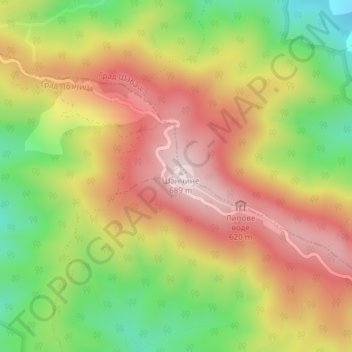
Nombre: Mapa topográfico Cer, altitud, relieve.
Altitud media: 480 m
Altitud mínima: 257 m
Altitud máxima: 681 m
Haz una donación
Otros mapas topográficos
Haga clic en un mapa para ver su topografía, su altitud y su relieve.
Mrovska
Serbia > Central Serbia > Macva Administrative District > Vladimirci Municipality
Altitud media: 182 m
Bogatic
Serbia > Central Serbia > Macva Administrative District > Bogatic Municipality
Altitud media: 84 m
Haz una donación
Donja Badanja
Serbia > Central Serbia > Macva Administrative District
Donja Badanja is a village located at the base of the mountain Cer and the low mountain Iverak, in the Jadar region. The Cernica River runs through Donja Badanja. The altitude of Donja Badanja is 180 -m-. Donja Badanja is connected by motorway to Šabac and Loznica, and further by highway to Belgrade. Donja…
Altitud media: 191 m
Haz una donación
Haz una donación
Ljubovija Municipality
Serbia > Central Serbia > Macva Administrative District > Ljubovija Municipality
Altitud media: 535 m
Haz una donación