
Mapa topográfico Mount Lamlam
Mapa interactivo
Haga clic en el mapa para ver la altitud.
Mount Lamlam
Rising to 406 meters (1,332 ft) above sea level, the distance from the peak to the bottom of the nearby Mariana Trench is said to be the greatest change in elevation on Earth over such a short distance.
Acerca de este mapa
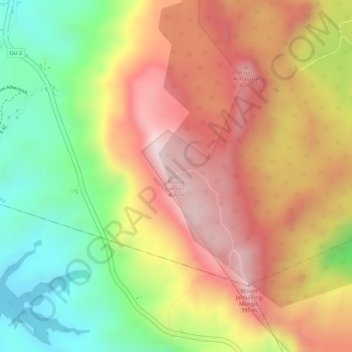
Nombre: Mapa topográfico Mount Lamlam, altitud, relieve.
Lugar: Mount Lamlam, Hågat Municipality, Guam, 96916, United States (13.33781 144.66668 13.33791 144.66678)
Altitud media: 223 m
Altitud mínima: 10 m
Altitud máxima: 395 m
Otros mapas topográficos
Haga clic en un mapa para ver su topografía, su altitud y su relieve.