
Gracias por apoyar a este sitio ❤️
Haz una donación
Haz una donación
Mapa topográfico Inks Lake State Park
Haga clic en el mapa para ver la altitud.
Gracias por apoyar a este sitio ❤️
Haz una donación
Haz una donación
Inks Lake State Park
Conservation Pool Elevation usually stays around 888.22 ft. msl; however, this lake does fluctuate about 1 foot annually. Inks lake water clarity can be seen as clear to slightly stained mostly throughout the year. It tends to have higher turbidity during the rainy season due to excessive amounts of runoff.
Gracias por apoyar a este sitio ❤️
Haz una donación
Haz una donación
Acerca de este mapa
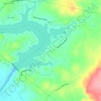
Nombre: Mapa topográfico Inks Lake State Park, altitud, relieve.
Altitud media: 294 m
Altitud mínima: 253 m
Altitud máxima: 383 m
Gracias por apoyar a este sitio ❤️
Haz una donación
Haz una donación