
Haz una donación
Mapa topográfico Boxford
Haga clic en el mapa para ver la altitud.
Haz una donación
Boxford
Boxford is divided into Boxford Village (commonly called East Boxford) and West Boxford Village, corresponding to the respective East and West Boxford centers. It is heavily forested and criss-crossed by various streams and brooks, many of which empty into the Ipswich River on Boxford's southern border. A number of ponds dot town as well, among them Stiles Pond, Cedar Pond, Spofford Pond, Lowe Pond, Four Mile Pond and Baldpate Pond. Throughout Boxford there are also a number of scenic hiking trails. The highest natural point in Boxford is Bald Hill, at an elevation of 243 feet (74 m). It sits in a corner of the Boxford State Forest, near Interstate 95 and the town's border with Middleton.
Haz una donación
Acerca de este mapa
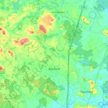
Nombre: Mapa topográfico Boxford, altitud, relieve.
Lugar: Boxford, Essex County, Massachusetts, 01921, United States (42.62068 -71.10863 42.73700 -70.94859)
Altitud media: 35 m
Altitud mínima: 7 m
Altitud máxima: 105 m
Haz una donación
Otros mapas topográficos
Haga clic en un mapa para ver su topografía, su altitud y su relieve.
Haz una donación
Little River Marshes
United States > Massachusetts > Essex County > Gloucester > West Gloucester
Altitud media: 27 m
Haz una donación
Blackwater River
United States > Massachusetts > Essex County > Salisbury > Salisbury Beach
Altitud media: 4 m
Haz una donación
Haz una donación
Haz una donación
Haz una donación
Haz una donación
Haz una donación
Haz una donación
Kettle Cove Village
United States > Massachusetts > Essex County > Manchester-by-the-Sea
Altitud media: 18 m
Haz una donación
Haz una donación
Haz una donación
Haz una donación
Haz una donación
Amesbury
United States > Massachusetts > Essex County > Amesbury
Amesbury is located at 42°51′29″N 70°55′50″W / 42.85806°N 70.93056°W / 42.85806; -70.93056. According to the United States Census Bureau, the city has a total area of 13.7 square miles (35.5 km2), of which 12.3 square miles (31.8 km2) is land and 1.5 square miles (3.8 km2), or 10.65%, is…
Altitud media: 24 m
East Parish
United States > Massachusetts > Essex County > Boxford > Boxford > East Parish
Altitud media: 38 m
Haz una donación
Haz una donación