
Gracias por apoyar a este sitio ❤️
Haz una donación
Haz una donación
Mapa topográfico Easton
Haga clic en el mapa para ver la altitud.
Gracias por apoyar a este sitio ❤️
Haz una donación
Haz una donación
Acerca de este mapa
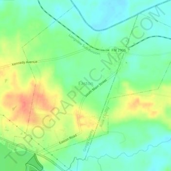
Nombre: Mapa topográfico Easton, altitud, relieve.
Lugar: Easton, Gregg County, Texas, 75641, United States (32.36450 -94.60902 32.39654 -94.56851)
Altitud media: 85 m
Altitud mínima: 65 m
Altitud máxima: 115 m
Gracias por apoyar a este sitio ❤️
Haz una donación
Haz una donación
Otros mapas topográficos
Haga clic en un mapa para ver su topografía, su altitud y su relieve.