
Haz una donación
Mapa topográfico Reward
Haga clic en el mapa para ver la altitud.
Haz una donación
Acerca de este mapa
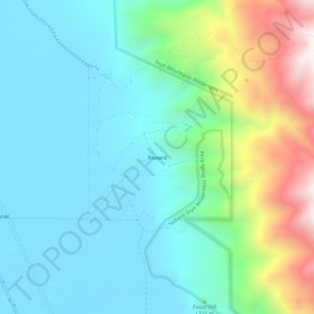
Nombre: Mapa topográfico Reward, altitud, relieve.
Lugar: Reward, Inyo County, California, United States (36.72743 -118.07509 36.76743 -118.03509)
Altitud media: 1.364 m
Altitud mínima: 1.128 m
Altitud máxima: 2.093 m
Haz una donación
Otros mapas topográficos
Haga clic en un mapa para ver su topografía, su altitud y su relieve.
Olancha
United States > California > Inyo County
Olancha (Timbisha: Pakwa' si) is a census designated place in Inyo County of the U.S. state of California. Olancha is located on U.S. Route 395 in California, 37 miles (60 km) south-southeast of Independence, at an elevation of 3658 feet (1115 m). As of the 2010 census, the population was 192, up from 134 at…
Altitud media: 1.200 m
Haz una donación
Cartago
United States > California > Inyo County
Cartago (Spanish for "Carthage") is a census-designated place in Inyo County, California, United States. Cartago is located on the west side of Owens Lake 3 miles (4.8 km) north-northwest of Olancha, at an elevation of 3629 feet (1106 m). The population was 92 at the 2010 census, down from 109 at the 2000…
Altitud media: 1.152 m
Haz una donación
Darwin
United States > California > Inyo County
Darwin is an unincorporated mining community in Inyo County, California, United States. It is located 22 miles (35 km) southeast of Keeler, at an elevation of 4,790 ft (1,460 m). The population was 43 at the 2010 census, down from 54 at the 2000 census.
Altitud media: 1.484 m
Round Valley
United States > California > Inyo County
Round Valley is a census-designated place (CDP) in Inyo County, California, United States. Round Valley is located 7.5 miles (12 km) northeast of Mount Tom, at an elevation of 4692 feet (1430 m). The population was 435 at the 2010 census, up from 278 at the 2000 census.
Altitud media: 1.491 m
Haz una donación