
Mapa topográfico Quaker Hill
Mapa interactivo
Haga clic en el mapa para ver la altitud.
Acerca de este mapa
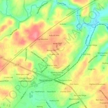
Nombre: Mapa topográfico Quaker Hill, altitud, relieve.
Altitud media: 94 m
Altitud mínima: 51 m
Altitud máxima: 135 m
Otros mapas topográficos
Haga clic en un mapa para ver su topografía, su altitud y su relieve.
Hockessin, Delaware
United States > Delaware > New Castle County > Hockessin, Delaware
Hockessin, Delaware, New Castle County, Delaware, United States
Altitud media: 96 m
Runnymeade
United States > Delaware > New Castle County > Hockessin, Delaware > Runnymeade
Runnymeade, Hockessin, Delaware, New Castle County, Delaware, 19707, United States
Altitud media: 92 m
Tree Top Valley
United States > Delaware > New Castle County > Hockessin, Delaware > Tree Top Valley
Tree Top Valley, Hockessin, Delaware, New Castle County, Delaware, 19707, United States
Altitud media: 93 m