
Haz una donación
Mapa topográfico Tustumena Lake
Haga clic en el mapa para ver la altitud.
Haz una donación
Acerca de este mapa
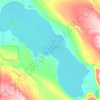
Nombre: Mapa topográfico Tustumena Lake, altitud, relieve.
Lugar: Tustumena Lake, Kenai Peninsula, Alaska, United States (60.03345 -151.16803 60.30056 -150.61378)
Altitud media: 197 m
Altitud mínima: 28 m
Altitud máxima: 732 m
Haz una donación
Otros mapas topográficos
Haga clic en un mapa para ver su topografía, su altitud y su relieve.
Homer
United States > Alaska > Kenai Peninsula
Many of the birds seen during the festival can be identified with the help of published guides that categorize distinguishable features such as, topography, silhouette, size, and color.
Altitud media: 104 m
Homer
United States > Alaska > Kenai Peninsula > Homer
Some birds seen during the spring migration and the festival include horned puffins, sandhill cranes, and arctic terns. Arctic Terns are famous for flying the longest distance of any migrating bird. Many of the birds seen during the festival can be identified with the help of published guides that categorize…
Altitud media: 106 m
Haz una donación