
Haz una donación
Mapa topográfico Westmont
Haga clic en el mapa para ver la altitud.
Haz una donación
Acerca de este mapa
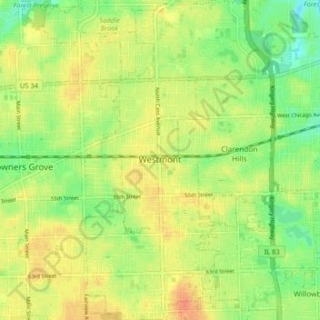
Nombre: Mapa topográfico Westmont, altitud, relieve.
Lugar: Westmont, DuPage County, Illinois, 60559, United States (41.76483 -87.99423 41.82505 -87.94695)
Altitud media: 227 m
Altitud mínima: 206 m
Altitud máxima: 244 m
Haz una donación
Otros mapas topográficos
Haga clic en un mapa para ver su topografía, su altitud y su relieve.
Elmhurst
United States > Illinois > DuPage County
Due to local topography, the town has had a tendency to flood in the past after large rainfalls; the city is currently undertaking a large effort to mitigate future flooding.
Altitud media: 207 m
Elmhurst
United States > Illinois > DuPage County
Due to local topography, the town has had a tendency to flood in the past after large rainfalls; the city is currently undertaking a large effort to mitigate future flooding.
Altitud media: 207 m
Haz una donación
Elmhurst
United States > Illinois > DuPage County
Due to local topography, the town has had a tendency to flood in the past after large rainfalls; the city is currently undertaking a large effort to mitigate future flooding.
Altitud media: 207 m