
Mapa topográfico Mount Fern
Mapa interactivo
Haga clic en el mapa para ver la altitud.
Acerca de este mapa
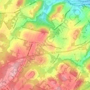
Nombre: Mapa topográfico Mount Fern, altitud, relieve.
Altitud media: 265 m
Altitud mínima: 171 m
Altitud máxima: 330 m
Otros mapas topográficos
Haga clic en un mapa para ver su topografía, su altitud y su relieve.
Shongum
United States > New Jersey > Morris County > Randolph Township
Shongum, Randolph Township, Morris County, New Jersey, 07869, United States
Altitud media: 248 m