
Mapa topográfico Whatcom County
Mapa interactivo
Haga clic en el mapa para ver la altitud.
Acerca de este mapa
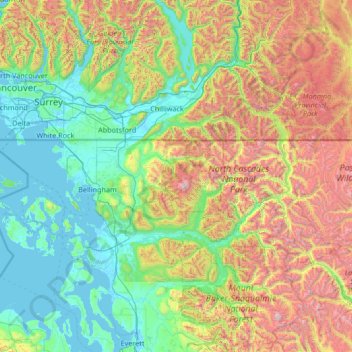
Nombre: Mapa topográfico Whatcom County, altitud, relieve.
Lugar: Whatcom County, Washington, VS (48.63525 -123.32224 49.00244 -120.65468)
Altitud media: 753 m
Altitud mínima: -3 m
Altitud máxima: 3.194 m
Otros mapas topográficos
Haga clic en un mapa para ver su topografía, su altitud y su relieve.
Mount Saint Helens
VS > Washington
Mount Saint Helens, Skamania County, Washington, VS
Altitud media: 2.108 m
Maple Valley
VS > Washington > Maple Valley
Maple Valley, King County, Washington, 98038, VS
Altitud media: 160 m
Mount Vernon
VS > Washington > Mount Vernon
Mount Vernon, Skagit County, Washington, VS
Altitud media: 37 m
First Hill
VS > Washington > Mercer Island
First Hill, Mercer Island, King County, Washington, 98040, VS
Altitud media: 31 m