
Mapa topográfico Ashton
Mapa interactivo
Haga clic en el mapa para ver la altitud.
Acerca de este mapa
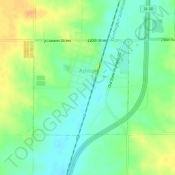
Nombre: Mapa topográfico Ashton, altitud, relieve.
Lugar: Ashton, Osceola County, Iowa, United States (43.30130 -95.80249 43.31600 -95.78225)
Altitud media: 448 m
Altitud mínima: 434 m
Altitud máxima: 467 m
Otros mapas topográficos
Haga clic en un mapa para ver su topografía, su altitud y su relieve.
Hawkeye Point
United States > Iowa > Osceola County
Hawkeye Point, Osceola County, Iowa, United States
Altitud media: 498 m
Sibley
United States > Iowa > Osceola County
Sibley, Osceola County, Iowa, United States
Altitud media: 462 m