
Mapa topográfico Town of Irondequoit
Mapa interactivo
Haga clic en el mapa para ver la altitud.
Acerca de este mapa
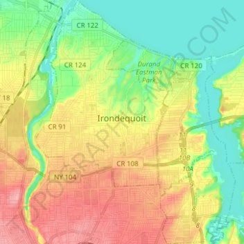
Nombre: Mapa topográfico Town of Irondequoit, altitud, relieve.
Lugar: Town of Irondequoit, Monroe County, New York, United States (43.16667 -77.62319 43.25704 -77.52184)
Altitud media: 110 m
Altitud mínima: 68 m
Altitud máxima: 163 m
Otros mapas topográficos
Haga clic en un mapa para ver su topografía, su altitud y su relieve.
Town of Riga
United States > New York > Monroe County
Town of Riga, Monroe County, New York, 14428, United States
Altitud media: 185 m
Belcoda
United States > New York > Monroe County
Belcoda, Town of Wheatland, Monroe County, New York, 14511, United States
Altitud media: 196 m
Town of Penfield
United States > New York > Monroe County
Town of Penfield, Monroe County, New York, United States
Altitud media: 135 m
Ellison Park
United States > New York > Monroe County > Penfield
Ellison Park, Brighton, Penfield, Monroe County, New York, United States
Altitud media: 112 m
Pittsford
United States > New York > Monroe County > Pittsford
Pittsford, Monroe County, New York, United States
Altitud media: 147 m
Town of Webster
United States > New York > Monroe County
Town of Webster, Monroe County, New York, 14580, United States
Altitud media: 111 m
City of Rochester
United States > New York > Monroe County
City of Rochester, Monroe County, New York, United States
Altitud media: 129 m
Village of Spencerport
United States > New York > Monroe County
Village of Spencerport, Town of Ogden, Monroe County, New York, 14559, United States
Altitud media: 164 m