
Haz una donación
Mapa topográfico Bhubaneshwar
Haga clic en el mapa para ver la altitud.
Haz una donación
Bhubaneshwar
Bhubaneswar is in Khordha district of Odisha. It is in the eastern coastal plains, along the axis of the Eastern Ghats mountains. The city has an average altitude of 45 m (148 ft) above sea level. It lies southwest of the Mahanadi River that forms the northern boundary of Bhubaneswar metropolitan area, within its delta.
Haz una donación
Acerca de este mapa
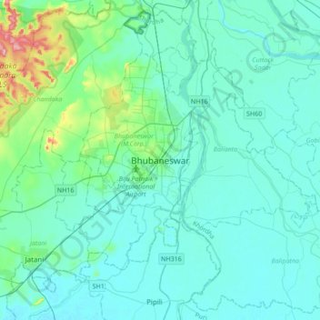
Nombre: Mapa topográfico Bhubaneshwar, altitud, relieve.
Altitud media: 30 m
Altitud mínima: 6 m
Altitud máxima: 199 m
Haz una donación
Otros mapas topográficos
Haga clic en un mapa para ver su topografía, su altitud y su relieve.
Ward 44
India > Odisha > Bhubaneswar (M.Corp.) > Bhubaneswar Municipal Corporation
Altitud media: 21 m
Ward 43
India > Odisha > Bhubaneswar (M.Corp.) > Bhubaneswar Municipal Corporation
Altitud media: 28 m
Netaji Subash chandra Bose Park
India > Odisha > Bhubaneswar (M.Corp.) > Bhubaneswar Municipal Corporation
Altitud media: 34 m
Haz una donación