
Mapa topográfico Gutmaning
Haga clic en el mapa para ver la altitud.
Acerca de este mapa
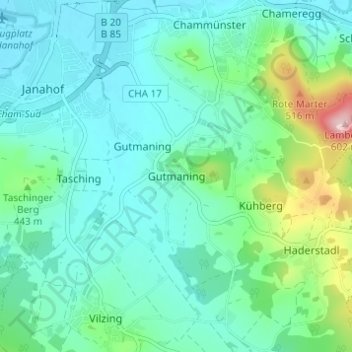
Nombre: Mapa topográfico Gutmaning, altitud, relieve.
Lugar: Gutmaning, Cham, Landkreis Cham, Bayern, 93413, Deutschland (49.17318 12.66941 49.21318 12.70941)
Altitud media: 412 m
Altitud mínima: 365 m
Altitud máxima: 592 m
Otros mapas topográficos
Haga clic en un mapa para ver su topografía, su altitud y su relieve.
Schwedenschanze
Deutschland > Bayern > Landkreis Cham > Cham > Chammünster
Der Burgstall Schwedenschanze, bei der es sich vermutlich um die Reichsburg Cham handelt, ist eine abgegangene Höhenburg (Wallburg) auf dem 415 Meter hohen Galgenberg 35 Meter über dem Zusammenfluss von Chamb und Regen in der Gemarkung Altenstadt der Stadt Cham im oberpfälzischen Landkreis Cham in Bayern.…
Altitud media: 385 m