
Haz una donación
Mapa topográfico Nuptse I
Haga clic en el mapa para ver la altitud.
Haz una donación
Nuptse I
Nuptse or Nubtse (Sherpa: ནུབ་རྩེ། नुबचे, Wylie: Nub rtse, Chinese: 努子峰) is a mountain in the Khumbu region of the Mahalangur Himal, in the Nepalese Himalayas. It lies 2 km (1.2 mi) WSW of Mount Everest. The main peak, Nuptse I at an elevation of 7,861 m (25,791 ft), was first climbed on May 16, 1961, by Dennis Davis and Sherpa Tashi. After a hiatus of almost 20 years, Nuptse again became the objective of mountaineers, with important routes being put up on its west, south, and north faces.
Haz una donación
Acerca de este mapa
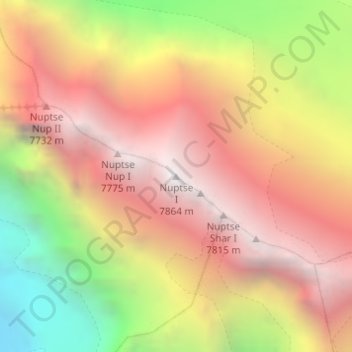
Nombre: Mapa topográfico Nuptse I, altitud, relieve.
Lugar: Nuptse I, Khumbupasanglahmu, Solukhumbu, Koshi Province, Nepal (27.96732 86.88691 27.96742 86.88701)
Altitud media: 6.833 m
Altitud mínima: 5.456 m
Altitud máxima: 7.832 m
Haz una donación
Otros mapas topográficos
Haga clic en un mapa para ver su topografía, su altitud y su relieve.