
Mapa topográfico Patna
Haga clic en el mapa para ver la altitud.
Patna
Patna is on the southern bank of the river Ganges. The total area of Patna is 250 km2 (97 sq mi). The municipal area constitutes 109.218 km2 (42.169 sq mi). The suburban area covers 140.782 km2 (54.356 sq mi). It has an average elevation of 53 m (174 ft). A characteristic feature of the geography of Patna is its confluence of major rivers.
Acerca de este mapa
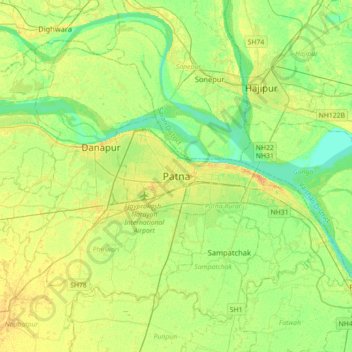
Nombre: Mapa topográfico Patna, altitud, relieve.
Lugar: Patna, Patna Rural, Patna, Bihar, 800001, India (25.44932 84.96353 25.76932 85.28353)
Altitud media: 51 m
Altitud mínima: 39 m
Altitud máxima: 65 m
Otros mapas topográficos
Haga clic en un mapa para ver su topografía, su altitud y su relieve.
Patna
India > Bihar > Patna Rural
Patna is on the southern bank of the river Ganges. The total area of Patna is 250 km2 (97 sq mi). The municipal area constitutes 109.218 km2 (42.169 sq mi). The suburban area covers 140.782 km2 (54.356 sq mi). It has an average elevation of 53 m (174 ft). A characteristic feature of the geography of Patna is…
Altitud media: 51 m