
Gracias por apoyar a este sitio ❤️
Haz una donación
Haz una donación
Mapa topográfico Guildhall
Haga clic en el mapa para ver la altitud.
Gracias por apoyar a este sitio ❤️
Haz una donación
Haz una donación
Guildhall
The highest point is Stone Mountain, in the western part of town, with an elevation of 2,736 feet (834 m).
Gracias por apoyar a este sitio ❤️
Haz una donación
Haz una donación
Acerca de este mapa
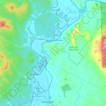
Nombre: Mapa topográfico Guildhall, altitud, relieve.
Lugar: Guildhall, Essex County, Vermont, United States (44.48486 -71.70712 44.61176 -71.55677)
Altitud media: 351 m
Altitud mínima: 246 m
Altitud máxima: 924 m
Gracias por apoyar a este sitio ❤️
Haz una donación
Haz una donación
Otros mapas topográficos
Haga clic en un mapa para ver su topografía, su altitud y su relieve.