
Gracias por apoyar a este sitio ❤️
Haz una donación
Haz una donación
Mapa topográfico Port Byron
Haga clic en el mapa para ver la altitud.
Gracias por apoyar a este sitio ❤️
Haz una donación
Haz una donación
Acerca de este mapa
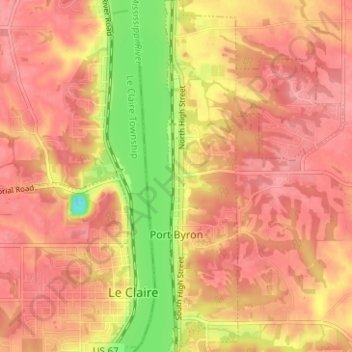
Nombre: Mapa topográfico Port Byron, altitud, relieve.
Lugar: Port Byron, Rock Island County, Illinois, United States (41.59065 -90.33787 41.63748 -90.30611)
Altitud media: 202 m
Altitud mínima: 142 m
Altitud máxima: 227 m
Gracias por apoyar a este sitio ❤️
Haz una donación
Haz una donación
Otros mapas topográficos
Haga clic en un mapa para ver su topografía, su altitud y su relieve.
Moline
United States > Illinois > Rock Island County > Moline
Moline witnessed a continued population increase after World War II with the completion of "Molette", a subdivision of mass-produced starter homes selling for $5,000 each. Molette was the first Moline neighborhood produced on a mass scale and one of the largest single-unit housing projects in the Midwest at…
Altitud media: 210 m