
Haz una donación
Mapa topográfico Lee Vining
Haga clic en el mapa para ver la altitud.
Haz una donación
Lee Vining
Lee Vining (formerly Leevining, Poverty Flat, and Lakeview) is an unincorporated community and census-designated place (CDP) in Mono County, California, United States. It is located 25 miles (40 km) south-southeast of Bridgeport, at an elevation of 6,781 feet (2,067 m). Lee Vining is located on the southwest shore of Mono Lake. The population was 217 as of the 2020 census.
Haz una donación
Acerca de este mapa
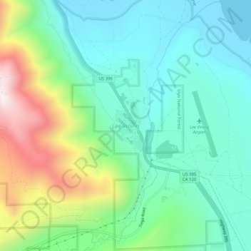
Nombre: Mapa topográfico Lee Vining, altitud, relieve.
Lugar: Lee Vining, Mono County, California, 93541, United States (37.93743 -119.14182 37.97743 -119.10182)
Altitud media: 2.180 m
Altitud mínima: 1.945 m
Altitud máxima: 2.768 m
Haz una donación
Otros mapas topográficos
Haga clic en un mapa para ver su topografía, su altitud y su relieve.
Mono Lake
United States > California > Mono County
Lake Russell was the prehistoric predecessor to Mono Lake, during the Pleistocene. Its shoreline reached the modern-day elevation of 7,480 feet (2,280 m), about 1,100 feet (330 m) higher than the present-day lake. As of 1.6 million years ago, Lake Russell discharged to the northeast, into the Walker River…
Altitud media: 2.008 m
Haz una donación
Haz una donación