
Mapa topográfico Hameau des Cordeliers
Mapa interactivo
Haga clic en el mapa para ver la altitud.
Acerca de este mapa
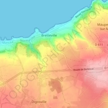
Nombre: Mapa topográfico Hameau des Cordeliers, altitud, relieve.
Altitud media: 78 m
Altitud mínima: -1 m
Altitud máxima: 159 m
Otros mapas topográficos
Haga clic en un mapa para ver su topografía, su altitud y su relieve.
Le Hardelle
France > Normandie > Manche > Bretteville
Le Hardelle, Bretteville, Cherbourg, Manche, Normandie, France métropolitaine, 50110, France
Altitud media: 50 m
Le Grand Heu
France > Normandie > Manche > Bretteville
Le Grand Heu, Bretteville, Cherbourg, Manche, Normandie, France métropolitaine, 50110, France
Altitud media: 39 m