
Haz una donación
Mapa topográfico Notch Peak
Haga clic en el mapa para ver la altitud.
Haz una donación
Acerca de este mapa
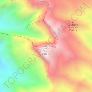
Nombre: Mapa topográfico Notch Peak, altitud, relieve.
Lugar: Notch Peak, Millard County, Utah, United States (39.14315 -113.40931 39.14325 -113.40921)
Altitud media: 2.434 m
Altitud mínima: 1.870 m
Altitud máxima: 2.910 m
Haz una donación
Otros mapas topográficos
Haga clic en un mapa para ver su topografía, su altitud y su relieve.
Fillmore
United States > Utah > Millard County
Fillmore is located at an elevation of 5,135 feet (1,565 m) in elevation. It lies in the Pahvant Valley, near the base of the Pahvant Mountain Range.
Altitud media: 1.584 m
Delta
United States > Utah > Millard County
Delta experiences a cold semi-arid climate (Köppen BSk) with hot summers and cold winters. Because of Delta's altitude and aridity, temperatures drop quickly after sunset, especially in the summer. Winters are cold. Daytime highs in the winter are usually above freezing, but nighttime lows drop well below…
Altitud media: 1.417 m
Haz una donación