
Mapa topográfico Gwalior
Haga clic en el mapa para ver la altitud.
Gwalior
Gwalior is located at 26°13′N 78°11′E / 26.22°N 78.18°E / 26.22; 78.18. in northern Madhya Pradesh 300 km (186 miles) from Delhi. It has an average elevation of 197 metres (646 feet). Most part of it comes under the Bundelkhand area.
Acerca de este mapa
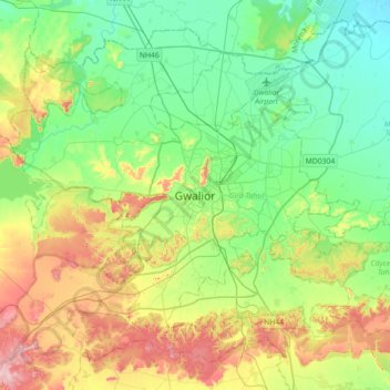
Nombre: Mapa topográfico Gwalior, altitud, relieve.
Lugar: Gwalior, Gird Tahsil, Gwalior, Madhya Pradesh, 474001, India (26.04372 77.99736 26.36372 78.31736)
Altitud media: 235 m
Altitud mínima: 165 m
Altitud máxima: 382 m