
Gracias por apoyar a este sitio ❤️
Haz una donación
Haz una donación
Mapa topográfico The Pines
Haga clic en el mapa para ver la altitud.
Gracias por apoyar a este sitio ❤️
Haz una donación
Haz una donación
Acerca de este mapa
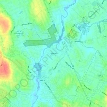
Nombre: Mapa topográfico The Pines, altitud, relieve.
Altitud media: 41 m
Altitud mínima: 25 m
Altitud máxima: 79 m
Gracias por apoyar a este sitio ❤️
Haz una donación
Haz una donación
Otros mapas topográficos
Haga clic en un mapa para ver su topografía, su altitud y su relieve.
Concord River
United States > Massachusetts > Middlesex County > Billerica
The river begins in Middlesex County, formed by the confluence of the Sudbury and Assabet Rivers at Egg Rock, near the Concord town center. It flows generally north, from eastern Concord (along the northwestern edge of the Boston metropolitan area), joining the Merrimack River from the south on the eastern…
Altitud media: 50 m