
Mapa topográfico Südholland
Mapa interactivo
Haga clic en el mapa para ver la altitud.
Acerca de este mapa
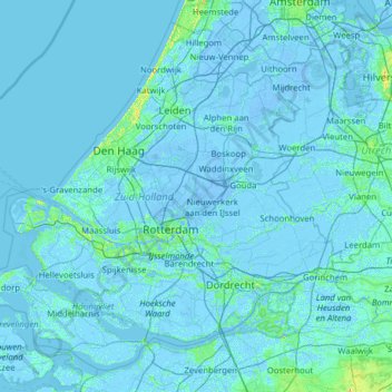
Nombre: Mapa topográfico Südholland, altitud, relieve.
Lugar: Südholland, Niederlande (51.64378 3.77368 52.33251 5.03142)
Altitud media: 0 m
Altitud mínima: -8 m
Altitud máxima: 35 m
Otros mapas topográficos
Haga clic en un mapa para ver su topografía, su altitud y su relieve.
Hoeksche Waard
Niederlande > Südholland > Hoeksche Waard
Hoeksche Waard, Südholland, Niederlande
Altitud media: 0 m
Mijnsheerenland
Niederlande > Südholland > Hoeksche Waard
Mijnsheerenland, Hoeksche Waard, Südholland, Niederlande
Altitud media: 0 m
Bergschenhoek
Niederlande > Südholland > Lansingerland
Bergschenhoek, Lansingerland, Südholland, Niederlande
Altitud media: -3 m