
Gracias por apoyar a este sitio ❤️
Haz una donación
Haz una donación
Mapa topográfico Baldwin City
Haga clic en el mapa para ver la altitud.
Gracias por apoyar a este sitio ❤️
Haz una donación
Haz una donación
Acerca de este mapa
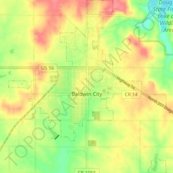
Nombre: Mapa topográfico Baldwin City, altitud, relieve.
Lugar: Baldwin City, Douglas County, Kansas, United States (38.75298 -95.21429 38.80099 -95.15812)
Altitud media: 323 m
Altitud mínima: 286 m
Altitud máxima: 355 m
Gracias por apoyar a este sitio ❤️
Haz una donación
Haz una donación
Otros mapas topográficos
Haga clic en un mapa para ver su topografía, su altitud y su relieve.
Lawrence
United States > Kansas > Douglas County > Lawrence
Downtown Lawrence is located at 38°58′18″N 95°14′7″W / 38.97167°N 95.23528°W / 38.97167; -95.23528 (38.959902, −95.253199), approximately 25 miles (40 kilometers) east of Topeka, and 35 mi (56 km) west of Kansas City, Kansas. Though Lawrence has a designated elevation of 866 feet (264…
Altitud media: 283 m