
Gracias por apoyar a este sitio ❤️
Haz una donación
Haz una donación
Mapa topográfico Newport Beach
Haga clic en el mapa para ver la altitud.
Gracias por apoyar a este sitio ❤️
Haz una donación
Haz una donación
Newport Beach
Newport Beach extends in elevation from sea level to the 1,161 ft (354 m) summit of Signal Peak in the San Joaquin Hills, but the official elevation is 25 ft (7.6 m) above sea level at a location of 33°37′0″N 117°53′51″W / 33.61667°N 117.89750°W / 33.61667; -117.89750 (33.616671, −117.897604).
Gracias por apoyar a este sitio ❤️
Haz una donación
Haz una donación
Acerca de este mapa
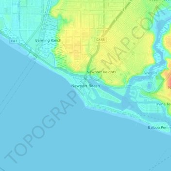
Nombre: Mapa topográfico Newport Beach, altitud, relieve.
Altitud media: 9 m
Altitud mínima: -1 m
Altitud máxima: 51 m
Gracias por apoyar a este sitio ❤️
Haz una donación
Haz una donación