
Mapa topográfico Leadville
Mapa interactivo
Haga clic en el mapa para ver la altitud.
Acerca de este mapa
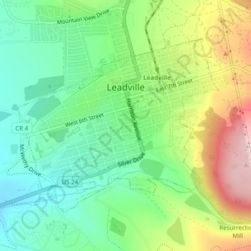
Nombre: Mapa topográfico Leadville, altitud, relieve.
Lugar: Leadville, Lake County, Colorado, 80461, United States (39.23730 -106.30754 39.25598 -106.27958)
Altitud media: 3.106 m
Altitud mínima: 3.023 m
Altitud máxima: 3.247 m
The City of Leadville is a statutory city that is the county seat, the most populous community, and the only incorporated municipality in Lake County, Colorado, United States. The city population was 2,602 at the 2010 census and an estimated 2,762 in 2018. It is situated at an elevation of 10,152 feet (3,094 m). Leadville is the highest incorporated city in the United States and it is surrounded by two of the tallest 14,000 foot peaks in the state.
Otros mapas topográficos
Haga clic en un mapa para ver su topografía, su altitud y su relieve.
Mount Sherman
United States > Colorado > Lake County
Mount Sherman, Lake County, Colorado, United States
Altitud media: 3.989 m
Leadville
United States > Colorado > Lake County
Leadville, Lake County, Colorado, 80461, United States
Altitud media: 3.106 m
Mount Elbert
United States > Colorado > Lake County
Mount Elbert, Lake County, Colorado, United States
Altitud media: 3.958 m
Lake County
United States > Colorado > Lake County
Lake County, Colorado, United States
Altitud media: 3.398 m