
Haz una donación
Mapa topográfico Kotdwar
Haga clic en el mapa para ver la altitud.
Haz una donación
Kotdwar
Kotdwar lies on the western margin of the Himalayas, at an altitude of 454 m (1,490 ft) above sea level.
Haz una donación
Acerca de este mapa
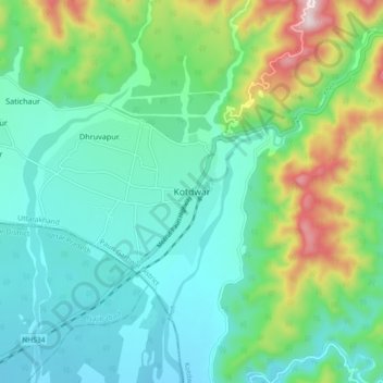
Nombre: Mapa topográfico Kotdwar, altitud, relieve.
Lugar: Kotdwar, Kotdwara, Pauri Garhwal, Uttarakhand, 246149, India (29.70598 78.48014 29.78598 78.56014)
Altitud media: 471 m
Altitud mínima: 324 m
Altitud máxima: 910 m
Haz una donación
Otros mapas topográficos
Haga clic en un mapa para ver su topografía, su altitud y su relieve.
Ramganga Dam
India > Uttarakhand > Kotdwara
The dam is a 128 m (420 ft) tall and 630 m (2,067 ft) long earth and rock-fill embankment dam with 10,000,000 m3 (13,079,506 cu yd) of fill. The dam's spillway is controlled by five gates and has a maximum discharge of 8,467 m3/s (299,009 cu ft/s). To support the reservoir's elevation, there is a 72 m (236 ft)…
Altitud media: 389 m
Haz una donación