
Haz una donación
Mapa topográfico Tres Piedras
Haga clic en el mapa para ver la altitud.
Haz una donación
Tres Piedras
Tres Piedras is located approximately 30 miles northwest of Taos, and west of the Rio Grande on U.S. Route 64. At approximately 8,000 feet (2,400 m) in altitude, it is located within the southern portion of the San Juan Range of the Rocky Mountains. Tres Piedras is on the western edge of a sagebrush plain, with ponderosa pines growing throughout the village. The village is adjacent to the Carson National Forest. The ZIP Code for Tres Piedras is 87577.
Haz una donación
Acerca de este mapa
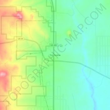
Nombre: Mapa topográfico Tres Piedras, altitud, relieve.
Altitud media: 2.476 m
Altitud mínima: 2.423 m
Altitud máxima: 2.572 m
Haz una donación
Otros mapas topográficos
Haga clic en un mapa para ver su topografía, su altitud y su relieve.
Taos
United States > New Mexico > Taos County
The elevation of the town is 6,969 feet (2,124 m). Just north of Taos is Wheeler Peak, at 13,161 feet (4,011 m), the highest point in New Mexico. Taos has a warm-summer humid continental climate (Köppen Dfb), though it borders on a semi-arid climate (BSk) due to the low rainfall. The town is characterized by…
Altitud media: 2.180 m
Haz una donación
Taos Ski Valley
United States > New Mexico > Taos County
Taos Ski Valley is a village and alpine ski resort in the southwestern United States, located in Taos County, New Mexico. The population was 69 at the 2010 census. Until March 19, 2008, it was one of four ski resorts in America to prohibit snowboarding. The Kachina lift, constructed in 2014, serves one of the…
Altitud media: 3.229 m
Haz una donación
Haz una donación
Taos Ski Valley
United States > New Mexico > Taos County
Taos Ski Valley is a village and alpine ski resort in the southwestern United States, located in Taos County, New Mexico. The population was 69 at the 2010 census. Until March 19, 2008, it was one of four ski resorts in America to prohibit snowboarding. The Kachina lift, constructed in 2014, serves one of the…
Altitud media: 3.229 m
Haz una donación
Taos
United States > New Mexico > Taos County
The elevation of the town is 6,969 feet (2,124 m). Just north of Taos is Wheeler Peak, at 13,161 feet (4,011 m), the highest point in New Mexico. Taos has a warm-summer humid continental climate (Köppen Dfb), though it borders on a semi-arid climate (BSk) due to the low rainfall. The town is characterized by…
Altitud media: 2.180 m